
Another set of materials that attract student interest are the maps drawn by school children in the early Republic as part of their primary education. We have been able to collect a number of these items; as beautiful works in their own right, these maps are also sought after by collectors of folk art.
The principle that children learn best by doing gained credence in the late 1700s and early 1800s. Some teachers incorporated geographical education into sewing and writing lessons. In her workbook, Catharine Cook copied a variety of astronomical and geographical information, including a summary of the zones and relational geographies for each state, as well as maps (item 30). Other teachers had students learn their geography by copying maps from printed texts (items 26-29). Mary Hall’s map of the USA is perhaps unique among such children’s maps (item 27). Rather than copy an entire map of the union, Mary seems to have compiled it from a number of maps of individual states. Starting in the northeast (the local place names suggests she was from Penobscot Bay area), she added states to the west and south, so that its spatial distortion progressively increases in those directions. On the adjacent wall is a large map made by Emily Hill (item 31), a teacher (we believe) from Vermont, who copied her work from one of the early versions of Abraham Bradley Jr.’s Map of the United States, exhibiting the post-roads … (various editions, 1796-ca.1825). We presume that she could not afford, or could not find a copy of, a printed map, and so copied a friend’s map. Note that the large expanse of paper was formed from several odd-shaped scraps, seamed together like a cloth quilt.

26. “A Map of the Countries situate about the North Pole as far as the 50th degree of north latitude,” ca.1820
Manuscript (ink and water color) on paper; 27cm diameter; 50cm x 34cm (paper)
Smith Collection
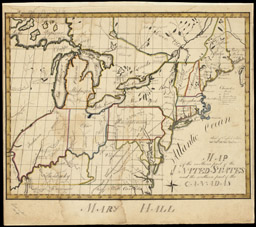
27. Mary Hall
“Map of the northern part of the United States and the southern part of the Canadas,” ca.1814
Manuscript (ink and water color) on paper; 36cm x 46cm
Osher Collection
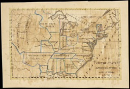
28. Esther Baldwin (b.1815)
“The United States | Esther Baldwin, sc. Age 12 years, AD 1827”
Manuscript (ink and water color) on paper; 29cm x 44cm
Osher Collection
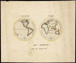
29. Amy Baldwin (b.1816)
“A Map of the World | Amy Baldwin sc. Age 11 years, 1827”
Manuscript (ink and water color) on paper; 33cm x 44cm
Osher Collection

30. Catharine M. Cook
“Catharine M. Cook’s Book of Penmanship at Mr. Dunham’s School, Windsor, Vermont, June 15th, 1818”
world map (p.10; shown in facsimile)
Manuscript (ink and water color) in notebook; 24cm high
Osher Collection

31. Emily Hill
“A Map of the United States of America,” 1820
Manuscript (ink and water color) on several joined sheets of paper; 101cm x 111cm
Osher Collection